
Gold Mountain Fire Information
UPDATED 7.2.26, 8:15 a.m.
The Gold Mountain Fire that originated in Ouray County has progressed to very near the southwestern Gunnison County line near Owl Creek Pass. The fire is at 18,005 acres with 0% containment.
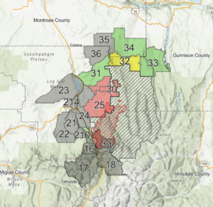
PRE-EVACUATION NOTICE: ZONE 33
The Gunnison County Sheriff has issued a Pre-Evacuation Notice for Zone 33 in southwest Gunnison County due to the Gold Mountain Fire. This is the area east of County Road 864A and West of Big Blue Creek, up to the BLM boundary; and south of the intersection of County Road 883 and County Road 864, also known as Little Cimmaron; and north of the Forest Service Boundary. This includes properties along Johnson Park Rd and Little Cimmaron Rd within this boundary.
This area is NOT on Evacuation order yet, but conditions may change quickly and we need you to be prepared and ready.
Please check the evacuation map here.
Pre-Evacuation means:
➡️ This area is NOT under a Voluntary or Mandatory Evacuation order yet, but your area is at high risk.
➡️Conditions may change quickly, and we need you to be prepared and ready in case a voluntary or mandatory evacuation is issued.
➡️If you require a longer time to evacuate due to medical issues, livestock needs, or other factors, we urge you to begin evacuation preparations immediately and be ready to leave at a moment's notice.
➡️I Be Prepared: Review your evacuation plan, assemble your Go Kit, and watch for emergency alerts. Sign up here https://emergency.gunnisoncounty.org/.
ZONE 32 REMAINS UNDER A VOLUNTARY EVACUATION NOTICE
This is the area south of Storm King, east of Cimmaron Ridge to County Rd 864A in the Cimmaron Valley to the US Forest Boundary southwest Gunnison County.
Please check the evacuation map here.
➡️ This area is NOT under a Mandatory Evacuation order yet, but your area is at high risk.
➡️ Conditions may change quickly, and we need you to be prepared and ready in case a mandatory evacuation is issued.
➡️ If you require a longer time to evacuate due to medical issues, livestock needs, or other factors, we urge you to begin evacuation preparations immediately and be ready to leave at a moment's notice.
➡️I Be Prepared: Review your evacuation plan, assemble your Go Kit, and watch for emergency alerts. Sign up here https://emergency.gunnisoncounty.org/.
Be aware that fire and law enforcement personnel will be working in this area. Please give them the space they need to work safely and efficiently and obey any directives provided.
An evacuation center/shelter has been set up at the Ridgway Secondary School (1200 Green St, Ridgway, CO 81432).
If you need to evacuate livestock/large animals (horses, cattle, goats, swine, sheep), the Montrose County Fairgrounds (1001 N 2nd St, Montrose, CO 81401) has been set up as an evacuation location. Call Jaime Goza at 970-275-5344 if you are bringing animals. Mandatory vet checks will be conducted on all animals entering.
Pets (cats/dogs) can be taken to the Montrose Animal Shelter at 3383 N. Townsend Ave, Montrose, CO 81403.
For questions on evacuations and road closures, call the Ouray County Evacuations Hotline at (970) 626-5484.
For fire information, call 970-325-3056 between 8:00 a.m. and 8:00 p.m.
*****Gunnison County Emergency Management is sending out Gunnison Regional Alerts to persons registered with addresses in the defined evacuation zones located within Gunnison County. You will not receive alerts if you do not live in zoned areas.
➡️For questions on evacuations and road closures, call the Ouray County Evacuations Hotline at (970) 626-5484.
➡️For fire information, call 970-325-3056 between 8:00 a.m. and 8:00 p.m. or email [email protected]
➡️For updated information on the Gold Mountain Fire, go to inciweb.wildfire.gov/incident-information/cogmf-gold-mountain-fire
-------------------------
UPDATED 7.1.26, 7:00 p.m.
The Gold Mountain Fire that originated in Ouray County has progressed to just west of the southwestern Gunnison County line near Owl Creek Pass. 16,559 acres with 0% containment.
A VOLUNTARY EVACUATION remains in effect for Zone 32 shown on the evacuation map in yellow: https://nifc.maps.arcgis.com/apps/instant/lookup/index.html?appid=a245e662d7d74b679c420acb6b20ba83.
This is the area south of Storm King, east of Cimmaron Ridge to County Rd 864A in the Cimmaron Valley to the US Forest Boundary southwest Gunnison County.
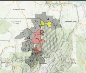
Review the map now if you live in the area of southwest Gunnison County to get familiar with your zone.
Additional Information
- The U.S. Forest Service has evacuated the Cow Creek, Big Cimarron, and Silver Jack Basin areas to the East Fork of the Cimarron River.
- Forest Service Road 858 (Cimarron Road) is closed (local traffic only) at U.S. Highway 50.
- For the safety of firefighters and the public, the Grand Mesa, Uncompahgre and Gunnison National Forests’ Ouray Ranger District has implemented a fire closure area in the vicinity of the Gold Mountain Fire. The closure area applies to all National Forest System lands within Ouray, Gunnison, and Hinsdale counties east of Hwy 550, south of Hwy 50, west of Pinnacle Ridge, north of Matterhorn Peak and Northeast of Cascade and Bridalveil creeks. The closure restricts public access to all lands, roads and trails within the described area.
For More Information
For questions about this incident, call 970-325-3056 between 8:00 a.m. and 8:00 p.m. or email [email protected].
For updated information about the Gold Mountain Fire, go to: https://www.facebook.com/GoldMountainFire or https://inciweb.wildfire.gov/incident-information/cogmf-gold-mountain-fire.
For up to date wildfire information across Colorado, visit Watch Duty: https://app.watchduty.org/.
To learn more about Evacuation Notice terminology, click here: https://emergency.gunnisoncounty.org/preparedness/